

Where does this example start and finish?
A is the published UCPA Val Thorens reference location. B is the base endpoint of M22 Pas du Lac 1 in the source map, in Méribel-Mottaret. B is not Méribel centre or a verified building entrance. Choosing another village or lift point can change the result.
Both coordinates snap to nearby graph nodes: about 29 m at the start and 11 m at the finish for the outbound blue calculation. The graph does not verify the actual access from the accommodation or to a lift boarding area.
Can you get from Val Thorens to Méribel on blue runs?
With a blue maximum and the fewest-transfers priority, this calculation connects the reference points using only green and blue tagged run segments, plus lifts and graph transfers. Its 13.8 km is total graph distance, including lifts; it is not 13.8 km of downhill skiing or a measured journey time.
The red-capped result has fewer lifts but is longer and includes red runs. Fewer transfers does not mean an easier, shorter or faster journey. Keep the difficulty you can ski; do not raise it simply to make a route appear.
Swipe the table horizontally to read all columns.
| Maximum piste difficulty | Graph result | What changes |
|---|---|---|
| Green only | No route found | No connection under this limit in the tested graph. |
| Blue allowed | About 13.8 km · 3 lift rides | Green and blue tagged pistes; no red or black run steps. |
| Red allowed | About 15.3 km · 2 lift rides | Includes the red-tagged Venturon; not an equivalent beginner route. |
Three lifts and the crossing towards Mottaret
The blue-capped lift sequence is VT31 Cairn → VT3 Plein Sud → VT4 Funitel 3 Vallées. After the crossing, the result includes Lac de la Chambre, Bouvreuil bleu, Mures Rouges, Ours and Truite towards the Mottaret reference point. Those are stored names, not a complete set of on-snow directions.
The result also contains unnamed sections and short graph transfers. Inspect the full result rather than following only this abbreviated name list.
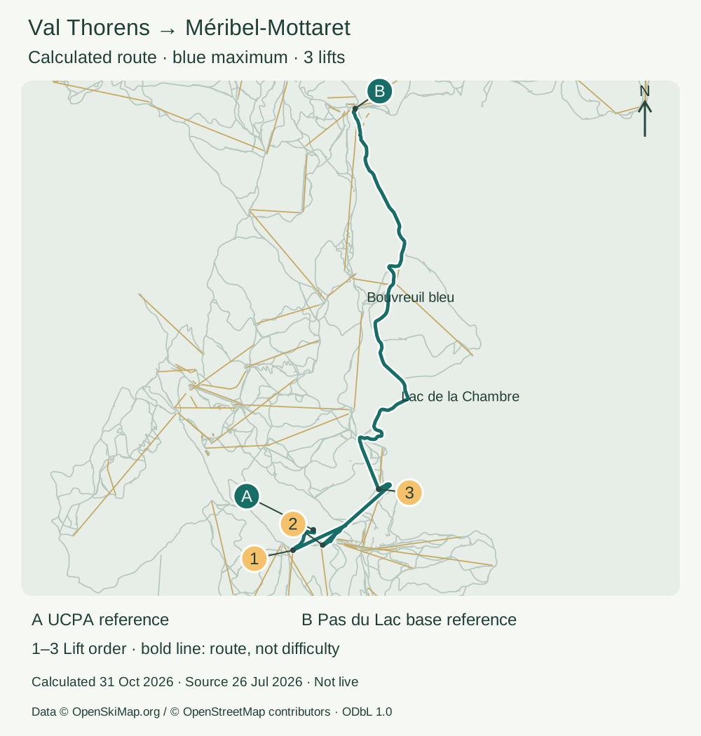
Swipe the table horizontally to read all columns.
| Map marker | Stored lift name |
|---|---|
| 1 | VT31 Cairn |
| 2 | VT3 Plein Sud |
| 3 | VT4 Funitel 3 Vallées |
How do you get back from Méribel to Val Thorens?
We reversed the reference endpoints and ran a separate blue-capped calculation: about 10.7 km with two lift rides, Plattieres → M74 Côte Brune. Named piste sections include Martre, Bouvreuil bleu, Mont de la Chambre and Traversée de Montaulever. The green-only return also finds no route in this graph.
This return differs from the outbound result. Before committing to a crossing, check both directions against the official piste map, current openings, your lift pass and the last operating times of the connections. We have not verified a same-day return on snow.
Try your own points, then prepare offline
In Mountainmapper on iPhone or Android, find the Les 3 Vallées area and choose the actual start and destination you intend to use. For a Mottaret endpoint, search Pas du Lac, select the first lift stage and inspect its base position. Choose your difficulty, review every leg and calculate the return separately. Exact selections, map versions and route preferences can change the result.
Before losing signal, download the map, search and routing data for the whole journey and test a short calculation in airplane mode. Starting guidance separately requires restriction information updated within 24 hours. The web diagram itself does not calculate a route or provide offline guidance.
Calculation date, map date and limits
Calculated on 31 October 2026 with Mountainmapper’s local piste-and-lift planner and the public Les Trois Vallées offline graph. The source snapshot is dated 26 July 2026. A new calculation date does not make that source current.
This is an independent calculation of these endpoints, not a cut-out of the Courchevel example. It does not test the full walking/transit planner, field access, operating status, queues or travel time.
Calculation inputs, source version and complete results
Start [longitude, latitude]: [6.56939, 45.29808]. Finish: [6.5800972, 45.3721291]. Priority: fewest_transfers; no avoidance preferences. Both directions were calculated with green, blue and red maximum grades.
Release: 019fbf84-870e-7f4b-afc9-a4367314a88e. The linked JSON records the graph version, package checksum, snaps, distances and all route steps.
Inspect the complete calculation (JSON)FAQ
Can I ski from Val Thorens to Méribel using only green runs?
No route was found for these reference points under a green-only limit in the tested graph. That is not proof about every possible endpoint. Keep your own level and ask the resort about an appropriate alternative.
Does the blue result go to Méribel centre?
No. Its destination is a source-map reference at the base of Pas du Lac 1 in Méribel-Mottaret. Méribel centre is a different destination and requires its own calculation.
Does the result prove that the connection is open?
No. It proves connectivity in the tested graph with the chosen difficulty. Check official openings, last lift times and local signs separately.